Because flood-producing precipitation is highly variable, floods may occur on a section of a single stream or many streams over a large geographic area. Although flooding can occur at any time, major floods on the primarily occur in winter and early spring as the result of heavy rains and/or snowmelt over large areas. Flood conditions along the White River in Indianapolis may continue for several days. Floods on other streams and drainage ways typically result from localized thunderstorms during the summer and fall. These “flash floods” rise and subside quickly sometimes within a few hours.
Flooding in Indianapolis has been aggravated by activities associated with urbanization. The presence of buildings, roadways, and other relatively impervious surfaces decreases the holding capacity of the underlying soil and increases storm runoff. Drainage of upland areas also increases runoff, which is rapidly delivered to drainageways through networks of ditches, culverts, drains, and other artificial channels. The dredging, clearing, widening, and straightening of natural waterways and the construction of levees and floodwalls further increase drainage efficiency, but may intensify flooding in downtown areas.
The development of floodplains also increases potential flood hazards. Riverfront areas that once were sparsely populated or used only as summer resorts now are fully developed for year-round residences and businesses. Any construction, filling, or dumping within the floodplain that reduces its cross-sectional area can obstruct flood flow, especially where high embankments impede overbank flows and where bridge openings are much smaller than the normal channel area.
In early Indianapolis, floods were of little concern because there was virtually no riverfront development. However as floodplains were converted to agricultural, commercial, industrial, and residential uses, the economic and social losses from floods increased. The adverse impacts of floods include property damage, erosion and deposition of sediments, sewer and drainage backwaters, crop losses, and occasionally the loss of human lives. Indirect damage includes the interruption of business, transportation, and commerce, and the associated loss of receipts and wages.
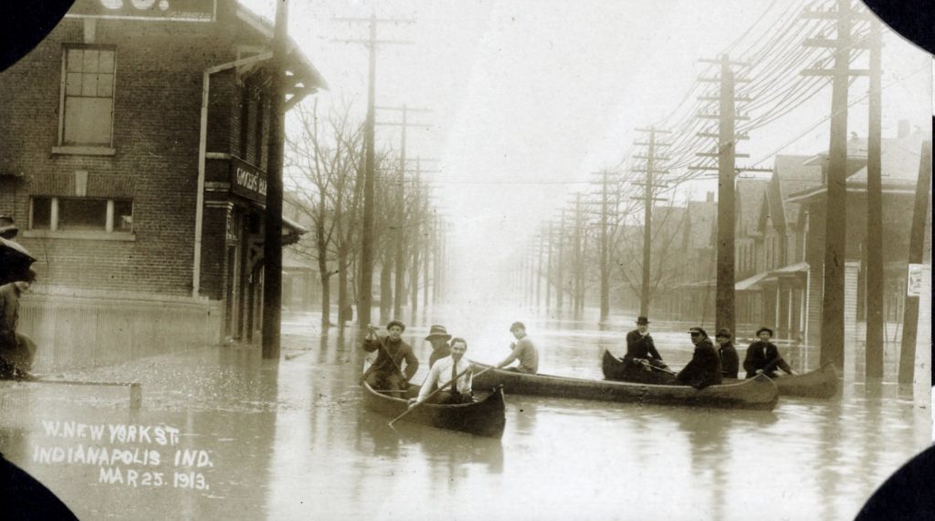
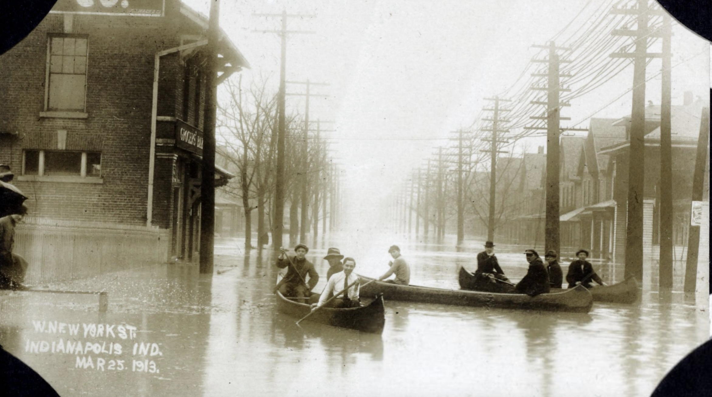
The most disastrous flood in Indiana history swept the state in March 1913. It was part of a regional flood disaster that devastated much of the Midwest and Ohio River valley, particularly Ohio and the central two-thirds of Indiana. Six inches of rainfall drenched Indianapolis over a five-day period that began Easter Sunday, March 23, 1913. Five-day rainfall amounts north of Indianapolis totaled up to 12 inches. Because the ground was already saturated from previous rains, the excess water quickly made its way to creeks and rivers.
The flood’s crest on White River near downtown Indianapolis was estimated at 31.5 feet, or 19.5 feet above flood stage; its exact height is unknown because the gauge washed away when the river reached 29.5 feet. The estimated peak discharge was 70,000 cubic feet per second (cfs), or 50 times greater than the average discharge of 1,398 cfs. (The second highest discharge of record on the White River at Morris Street was 37,200 cfs, which occurred during the May 1943, flood.) At the height of the 1913 flood, earthen levees along White River, , Eagle Creek, and Little Eagle Creek failed, sending torrents of water rushing through the city, especially the area formerly known as (roughly bounded by West Washington Street, White River Parkway, Raymond Street, and Belmont Avenue). Nearly all bridges, including the West Washington Street bridge, were washed away or irreparably damaged. The city’s public water supply was shut down for nearly four days, and normal transportation ceased in the flooded areas. Some areas in West Indianapolis were under 30 feet of water, and only the roofs of two-story houses were visible above the floodwaters.
In Indianapolis, about 7,000 families lost their homes, and as many as 25 deaths were reported but unconfirmed. Statewide the flood claimed 200 lives and left 200,000 homeless. A massive relief effort organized at both the local and state levels continued throughout the year as cities and residents rebuilt. In the capital, a General Relief Committee for Flood Sufferers operated for several months to assist those left in need with food, fuel, clothing, and temporary housing.
After the 1913 flood, the City of Indianapolis and later the Federal Works Progress Administration began implementing a comprehensive flood protection plan. The long-range plan included the construction of earth levees, concrete floodwalls, and associated facilities such as pumping stations and detention basins. The plan also included channel work such as dredging and straightening, bridge reconstruction, channel relocation, and utility alterations.
From the 1920s through the 1960s extensive flood protection projects and associated structures were completed along segments of the White River, Fall Creek, and Eagle Creek. Additional projects were conducted along Little Eagle Creek, , Pleasant Run, and other tributaries. Most large-scale projects were coordinated by the Indianapolis Flood Control District, a predecessor of the present-day The Works Progress Administration and the U.S. Army Corps of Engineers participated in several major projects, and the Indiana Flood Control and Water Resources Commission provided regulatory oversight and some financial assistance.
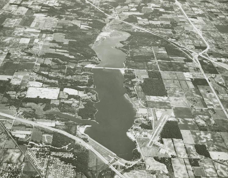
The construction of Eagle Creek Reservoir greatly reduced flooding on lower Eagle Creek by storing incoming floodwaters and slowly releasing excess flows. in northeastern Indianapolis and in were designed primarily for water supply purposes but can have some flood control benefits.
Channel modifications are notable along several streams. The major portion of flood flows from Dry Run on the city’s west side are diverted to Little Eagle Creek through Dry Run Diversion Ditch, which helps relieve flooding near the . On the north side of Indianapolis, about 35 percent of the flood flows on White River near Williams Creek are diverted through the Williams Creek Cutoff. In the downtown area, the lower 2.2 miles of Pogue’s Run are enclosed in an underground box culvert that carries runoff from low-intensity storms to its outlet at the White River near Kentucky Avenue. However, the culvert cannot carry peak flows from high-intensity storms, and floodwaters overflow at the culvert entrance.
In recent decades many channel improvements, realignments, and bridge modifications have been completed as part of highway and interstate construction programs, although these projects generally affect only short segments of the city’s watercourses. Since the 1960s most flood protection projects have focused on correcting drainage and flooding problems along selected reaches of tributary creeks.
In addition to structural measures, city and state agencies also use nonstructural means to alleviate flooding. The Indianapolis Flood Control District countywide zoning ordinance gives the Department of Public Works the authority to regulate any development within the identified floodplains of Indianapolis. Because the city participates in the National Flood Insurance Program (NFIP), this ordinance contains not only local building requirements but also all state and federal requirements. Through NFIR residents of Indianapolis are eligible to purchase federal flood insurance.
*Note: This entry is from the original print edition of the Encyclopedia of Indianapolis (1994). We are currently seeking an individual with knowledge of this topic to update this entry.

Help improve this entry
Contribute information, offer corrections, suggest images.
You can also recommend new entries related to this topic.