Monument Circle
Monument Circle through the Last Century
Monument Circle has been the center of Indianapolis since the city was first planned in 1820. Indianapolis’ transformations are reflected in the Circle, from a newly planned seat of government to a 19th-century commercial hub and eventually a contemporary corporate center.
Origins
From the start, the Circle represented the civic and cultural heart of Indianapolis. Originally, the Circle was planned as the location of the governor’s residence. The four blocks surrounding the Circle were designated as Governor’s Square in Alexander Ralston’s plan for Indianapolis. A mansion was built in the center of the Circle surrounded by a wooden fence. The Circle itself was an unpaved road. However, no governors ever used the home as their residence. Instead the building served as the early location for state offices and civic ceremonies. The city’s first churches were established on the Circle. Methodists, Presbyterians, and Episcopalians all established churches between 1829 and 1838.
Century of Development
By the early 20th Century, Indianapolis was booming as a regional center for manufacturing, agricultural distribution, and commerce. The Soldiers and Sailors Monument, opened in 1902, represented Indianapolis’ patriotic spirit. Its presence continued to make civic values the figurative and literal center of the city. Surrounding the monument, hotels, banks, and offices were a testament to the city’s booming economy.
While the earliest skyscrapers began appearing in Indianapolis in the 1920s, the buildings on the Circle were still only two to six stories. By 2020, most buildings on the circle were much taller, including the Art Deco-style Circle Tower, the modernist Indianapolis Power and Light Building, and the postmodern Salesforce Tower. Built in 1981, the Salesforce Tower is the tallest building in Indiana. It is predominantly located on Ohio Street but maintains a Monument Circle address through interior connections to the mid-century American Fletcher National Bank headquarters.
View from the Top
Since its construction, Soldiers and Sailors Monument has been a powerful vantage point from which to view the development of downtown Indianapolis. These two VR scenes compare the view from the top of the Monument in the early 20th century and the middle 20th century. By stitching together dozens of individual photographs, we see an approximate recreation of how it would have looked standing in the Soldiers and Sailors observation deck.
Use your mouse or finger to look around the 360 degree view. Learn more about that at IDIA LAB. (Images courtesy of Indiana Historical Society and Indiana Album)
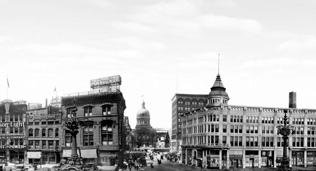
Early twentieth century (1890-1916)
Early twentieth century. This is a composite of images from 1890 to 1916. Looking north, you can see Christ Church Cathedral, an 1858 building that still stands today. The newly built (1903) U.S. Courthouse is visible one block north, and beyond that stands University Park. The Knights of Pythias Building is under construction on Massachusetts Avenue. It would be demolished in 1967 to make room for Regions Tower. Looking east on Market Street, the Fletcher Trust Building is one of the city’s first skyscrapers, unique at the time for its steel-frame construction. At 16 stories (218 feet) it was one of the tallest buildings in Indianapolis when built.
The Marion County Courthouse is visible on Washington Street. It was demolished in 1967 and replaced with the City-County Building. Looking south on Meridian Street, you can see the L.S. Ayres flagship store. In the distance, Union Station at this time would have been an active passenger rail hub. The station would have been about 30 years old at this point. Looking southwest and west, smokestacks in the distance are evidence of the heavy industry and manufacturing growing rapidly in the part of the city. The Statehouse would have been only 30 years old at this point. The Cyclorama, a short-lived but fascinating exhibit space, showed life-size Civil War murals and served as a menagerie during its 15-year existence. The English Hotel was located at 120 Monument Circle and was one of the city’s premier hotels at the beginning of the 20th century.
Mid-twentieth century (1958-1972)
Mid 20th century. This is a composite of images from 1958 to 1972. Looking north, Christ Church Cathedral still stands but is dwarfed by the Board of Trade Building (1907) to its north and Columbia Club (1925) to the east. American Fletcher National Bank built a new headquarters in 1959. The tower still stands today and is the entrance to Salesforce Tower. By the time these photos were taken, the brand new City-County Building (1962) has replaced the former courthouse. Looking south, the L.S. Ayres flagship store is expanded compared to the early 20th century images. The building’s frontage on Washington Street has doubled and expansions have added more capacity along South Meridian Street as well.
The Perry K. Steam Plant is located southeast on Kentucky Avenue. Built as the city’s first power plant, the facility now supplies downtown customers with district heat and cooling. Looking down at the southwest corner of the Circle, a fire crew is responding to a fire in 1958. Behind the Statehouse, the state government offices have expanded into the newly built Government Center North (1961). The building still stands today, though is clad in a different facade after remodeling in the 1990s. In the northwest corner of the Circle, the English Hotel has been replaced with a modernist J.C. Penney building.